1:24,000 Scale Surface Geology
Disclaimer
The views and conclusions contained in these documents/data are those of the authors and should not be interpreted as necessarily representing the official policies, either expressed or implied, of the U.S. Government or the state of Louisiana. These maps/data have been carefully prepared from the best existing sources available at the time of preparation. However, the Louisiana Geological Survey and Louisiana State University do not assume responsibility or liability for any reliance thereon. This information is provided with the understanding that it is not guaranteed to be correct or complete, and conclusions drawn from such data are the sole responsibility of the user. These regional geologic quadrangles are intended for use at the scale of 1:24,000. A detailed on-the-ground survey and analysis of a specific site may differ from these maps.
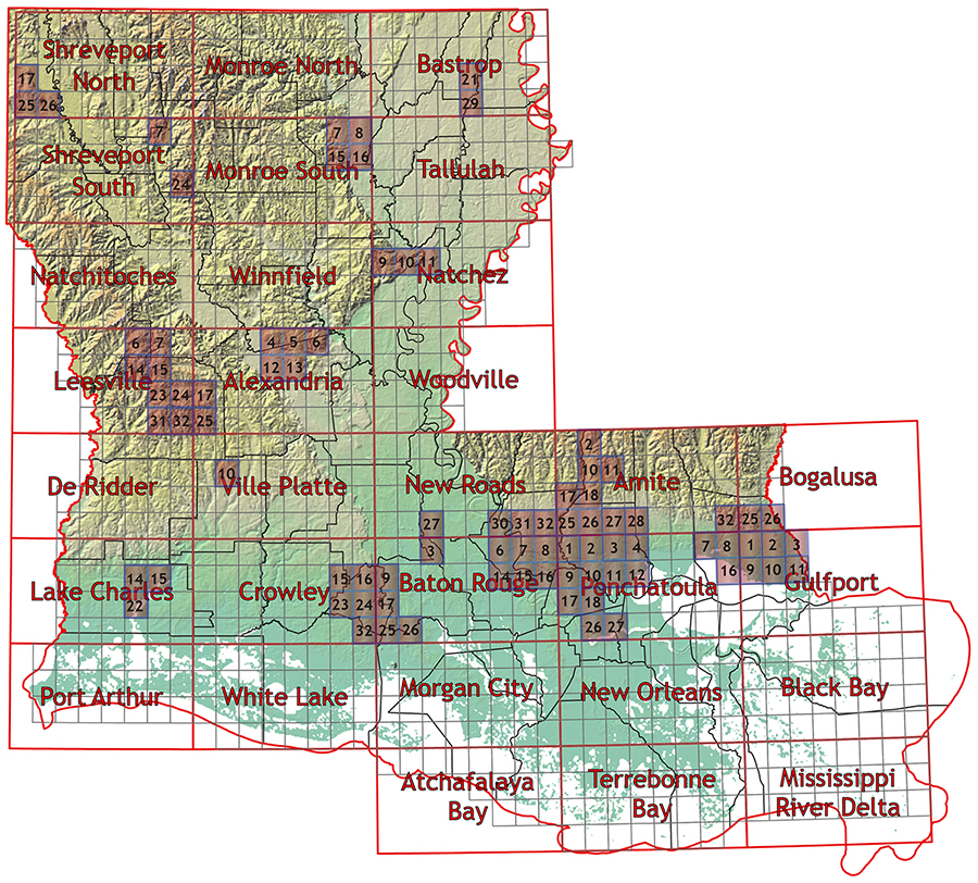
The 1:24,000 scale surface geology map series provides detailed, quadrangle-based coverage of Louisiana's surficial geologic units for scientific, educational, and planning applications. These maps depict the distribution of rock and sediment at or near the land surface, supporting work in groundwater and resource assessment, engineering geology, environmental site evaluation, and land-use decision-making. Produced by the Louisiana Geological Survey, each quadrangle follows a consistent cartographic and stratigraphic framework, and many are accompanied by descriptive pamphlets that summarize local geologic history, lithologies, and mapping methods. Digital shapefiles are available for most completed quadrangles, enabling direct integration into GIS workflows for analysis, visualization, and overlay with other spatial datasets. Users can consult the statewide index map to identify quadrangles of interest and then access corresponding PDFs, pamphlets, and geospatial data through the lists organized by map area. As additional mapping is completed and new technologies emerge, this series will continue to expand and be updated, enhancing the accessibility and utility of Louisiana's surface geology information.
While we strive to provide accessible content to all of our users, we are aware that some may experience barriers due a disability when utilizing our maps. As technology improves, we will continue to work towards creating more accessible alternatives in the future. If you are in need of assistance, please contact the Louisiana Geological Survey.
Descriptive pamphlets are available for recent maps. Click on the corresponding "Pamphlet" link to download the PDF document.
Open File - Shapefiles not yet available
Open File - Shapefiles not yet available
No data currently available for this region.
No data currently available for this region.
No data currently available for this region.
No data currently available for this region.
No data currently available for this region.
No data currently available for this region.
No data currently available for this region.
No data currently available for this region.
No data currently available for this region.
No data currently available for this region.
No data currently available for this region.
No data currently available for this region.
No data currently available for this region.
No data currently available for this region.